Ok..Day 2 started off cold...no way to describe it other than just cold. My roommates, decided 60 degrees was too hot in the room so they opened the window in the shack and left the door with at least 12 inches open. About 5am, I woke up huddled in my 20 degree mummy bag cold...hmmm... Needless to say, at 35 degrees, it was a cold morning cooking breakfast outside.
Moab is at ~4K feet or so and our trail head started at 9000ft. The Colorado crew, Wayne, Matt, and Pam dropped a car off at the end of the trail and came to show us how to get way up to the Hazard County trailhead. Saved a $20 shuttle ride per person.
Ok, here is the trailhead. We looked at doing the Whole Enchilada, but were told too much snow. Not sure how well us 200feet above sea level guys would do starting at 10,000 feet riding up with 11,500, before descending. The snow saved the ego and we decided to go for the 25 mile trip (which turned into 31 for Pam and I).
 After re-inserting our lungs, Matt arrives at 9500 feet past some nice trees.
 Wayne was like an Energizer Bunny....just kept going at a steady pace the whole day.
 When we got to the top, they made a really nice poster with all the points and canyons marked out in the background.
 Here is a panorama of the La Sal mountains in the background. We nearly hit 6 mule deer on the way to the trailhead. Pretty country.
 The gang before we start. By days end, 1 sprained wrist, 1 flat tire, and 1 bent derailleur hanger, priceless memories. Not bad for such a harsh ride. Leg pads were very nice to have as the rocks kicked up. Note the jackets, it was cold. I think the car said it was 33 when we started from the trailhead.
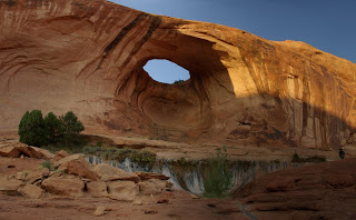
 Washington Matt caught some good contrast of Pam and the canyon rim we will be following all day. In later pictures, that spire in the middle is really close by the time we mid-way through the ride.
 Some gnarly flowing singletrack. Reminded me of when Crystal Mountain had lift serviced MTB trails. By skills at taking even picture for a panorama were impaired due to altitude. Note the trees below.
 Look at the trees above. It didn't take us long to reach this point and 1k feet down the mountain. Washington Matt with some extra lean around the corner.
 Pam came roaring around the corner, but managed to catch this picture.
 Scott had an uncanny ability today,to pick up everyones pieces as we tried to fall apart down the trail. The steel hardtail of 17 years, still going strong.
 Our path took us through a recent burn area. We noticed several guys on horseback that sure looked like law enforcement of some kind. Thought it kind of odd to see them on horse back, but imagine in this terrain, they can cover a lot of ground.
 I finally got Wanye to stop long enough to take a picture. Then he was off again.
 We came across an old abandoned/burned down house and Trey found this old vehicle in front. I guess it didn't' ride as well as his Steel Framed Hardtail, so he soon switched back to the bike and blasted down the hill, passing up several of us fully suspended guys.
 The trail came to a split, and Pam and I took one way, and the group took the other. This is where we were supposed to turn, but got too side tracked with cool rocks and missed the trail marker 20 feet up the road.
 While going the wrong way, we came across a random chair abandoned. Pam saw this as an excellent photo op. It wasn't until we started going up hill that Pam convinced me we were going the wrong way. Later we found we traveled nearly 2.5 miles the wrong way before turning around. Made for a long detour, but finally met up with the group. Cell phones are awesome to communicate such wrong turns.
 Some of the rocks as we descended. Sometimes it was hard to pick the right line down them cause you couldn't always see what was below.
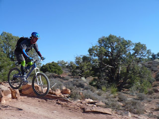
 San Diego Mike, showing us how to lean back and blast through the rock piles. That is what suspension and a carbon framed Ibis is for.
 Wayne catching some air of another randomly placed launch rock pile.
  Colorado Matt showing us some of his downhill skills, taking flight, yes he landed this just fine.
 The trail got right on the edge of the cliff face. Sometimes, too close for my taste.
 Hey...look at me...I'm pretending to be falling over...maybe not such a smart thing to do so close to the edge of the cliff.
 Remember the first couple picture, Pam was looking into the valley. Well, we are above that valley looking down.


